Environmental Impact Assessment guidance
The Agriculture, Land Drainage and Irrigation Projects (Environmental Impact Assessment) (Scotland) Regulations came into effect on 16 May 2017
The regulations came into effect on 16 May 2017 and are a tool to help RPID make decisions on certain agricultural projects and their effects.
Work on agricultural land: improving uncultivated semi-natural land, removing knowes, levelling fields, removing dykes and hedges, irrigation, and new drainage may require approval under these regulations (with some exemptions, see Annex 1).
The regulations require you to request a screening opinion from your local Rural Payments and Inspections Division (RPID) area office to determine if an Environmental Impact Assessment (EIA) will be required before you can start work on your project or not. It is important to note these EIA regulations are separate, and in addition to, the Cross Compliance regulations. A screening opinion will be required in the following circumstances:
1. a project involving the use of uncultivated land or semi-natural areas for intensive agricultural purposes. For example: spraying, liming, ploughing, draining, and reseeding such areas ( see Annex 2).
2. a project involving new irrigation
3. maintenance of existing drainage does not require a screening opinion, however a project involving new drainage does, where:
- the project, or any part of it, is to be carried out in a sensitive area ( Annex 3)
- the project is done wholly out with a sensitive area and the extent of the project exceeds one hectare
4. a project involving restructuring of rural land holdings on agricultural land where:
- the project, or any part of it, is to be carried out in a sensitive area ( Annex 3)
- the project is carried out wholly out with a sensitive area and the extent of the project is equal to or exceeds the threshold applicable to it
- if the restructuring project involves the addition or removal of any field boundary it must not equal or exceed 6 km in length
- if the field boundary removed comprises a hedge or a drystanedyke, then no more than 0.5 km of hedge or drystane dyke can be removed
- any new vehicle track constructed must not exceed 1km in length
- if the restructuring project involves an area of land, the area affected must not equal or exceed 200 hectares
- if the restructuring project involves the addition, removal, or redistribution of a volume of earth or other material in relation to land, the volume must not equal or exceed 5,000 cubic metres
Examples of projects like this could include scraping back topsoil, breaking up knowes, moving rock and soil to level fields.
A project may involve more than one type of restructuring referred to in section 4 above.
If any of the elements of the restructuring is above the threshold, the entire project is subject to the screening procedures.
A screening application form can be requested from your local RPID area office. We will confirm our screening decision as soon as possible and within 90 days unless the project is very large or complex.
If you carry out a project without first getting a screening decision, you will have committed an offence and, following conviction, would be liable to a fine. We also have the power to issue a stop notice bringing the work on the project to an immediate halt, or a reinstatement notice requiring the relevant land to be returned to the condition it was in before the project commenced.
Prosecution under EIA regulations does not prejudice RPID or any other public body from pursuing prosecution/penalisation under any other regulations.
If you have any questions or to check if your project will require a screening opinion, please contact your local RPID area office.
EIA farmer process and who to contact flow charts
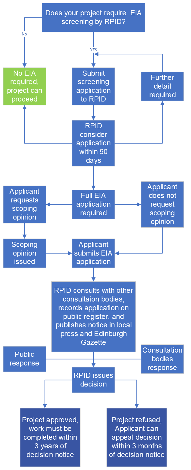
Brief overview of the EIA process
-
Brief overview of the EIA process
-
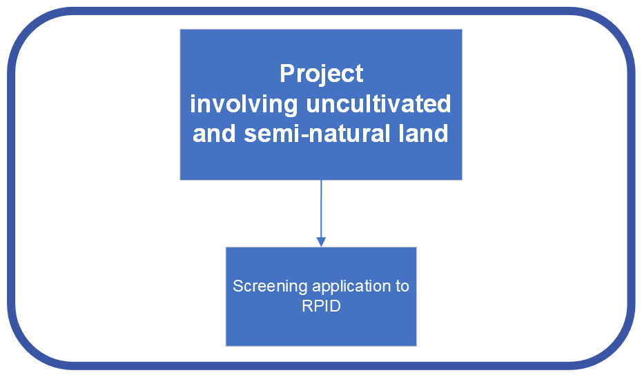
Who to contact for uncultivated and semi-natural land
-

Who to contact for boundary creation or removal
-
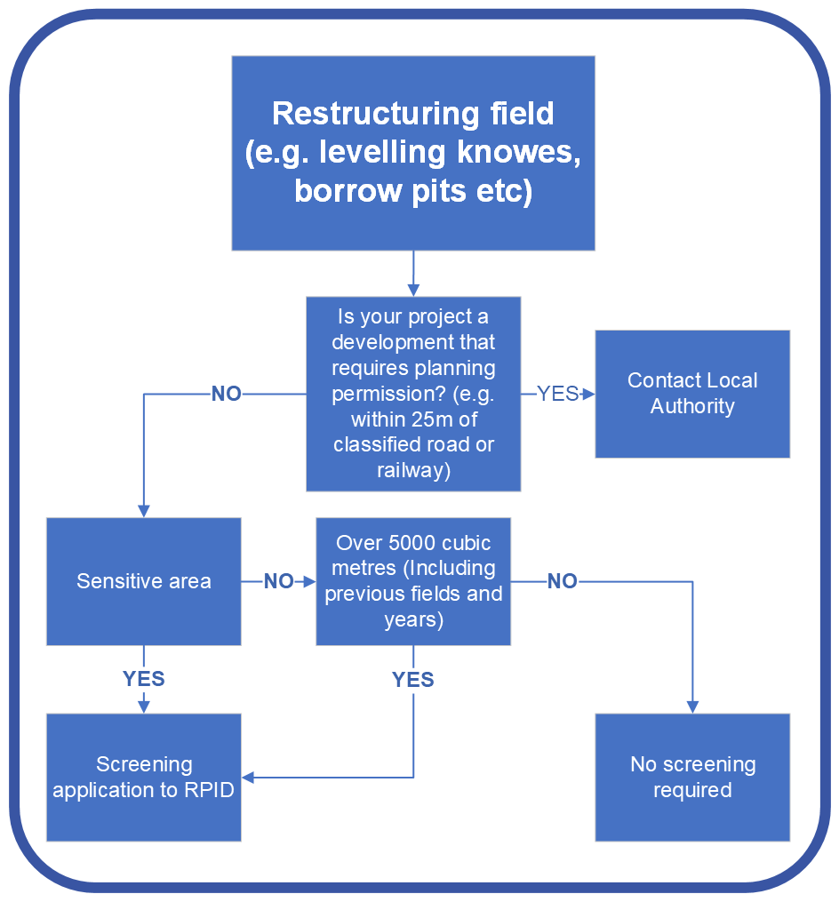
Who to contact for restructuring fields
-
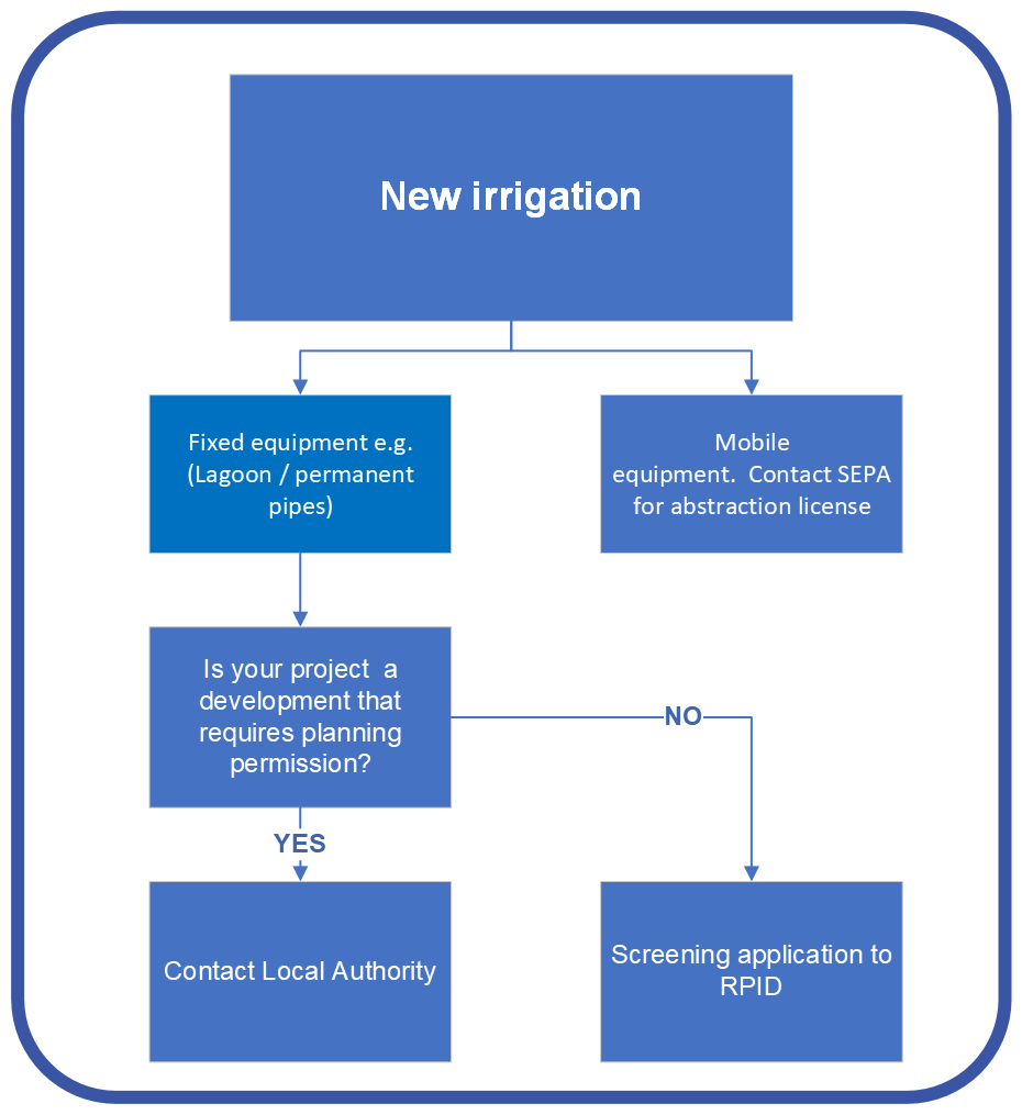
Who to contact for new irrigation
-
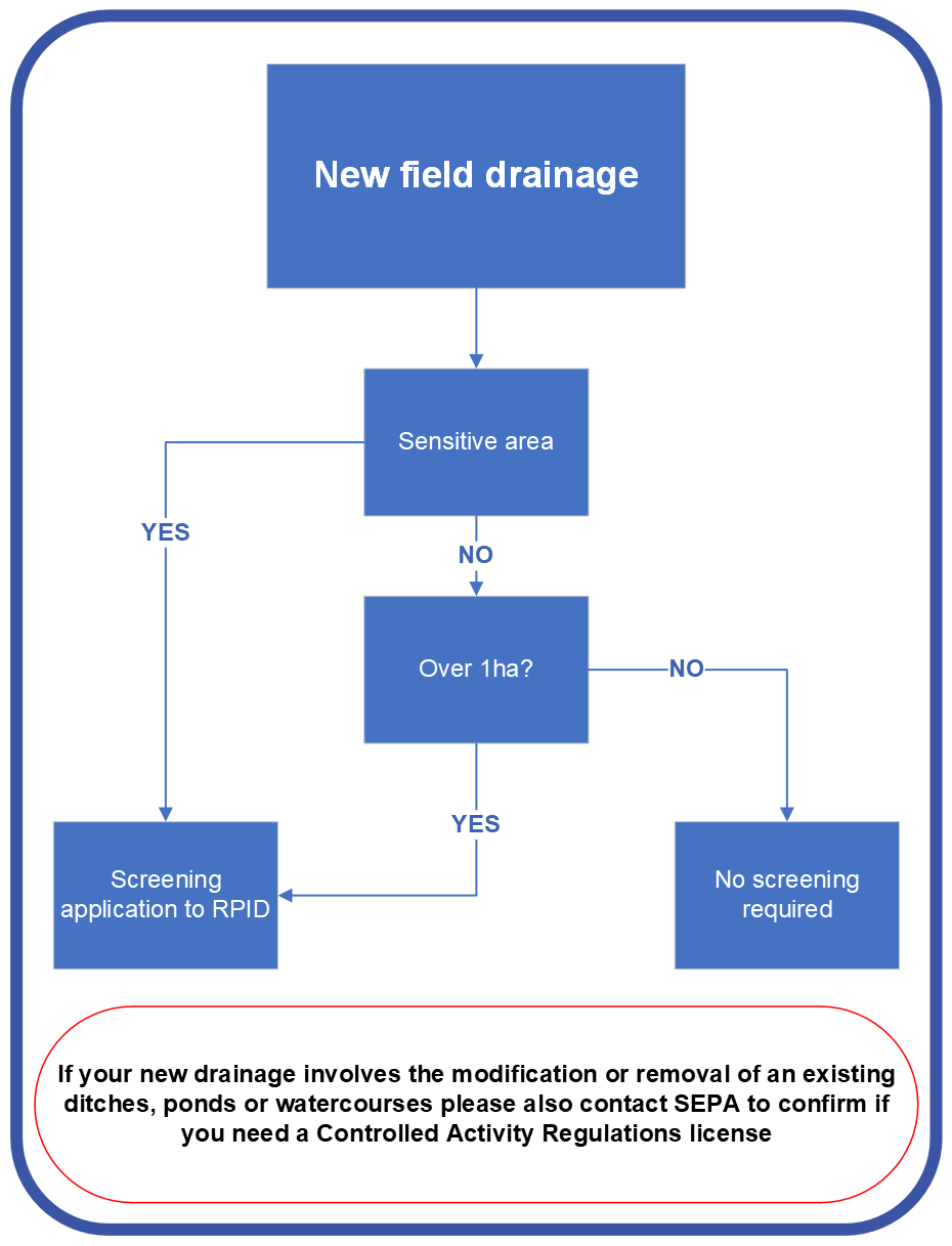
Who to contact for new field drainage
-
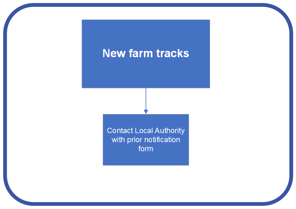
Who to contact for new farm tracks
-

For forestry projects, contact scottish forestry
Glossary of terms
Screening
A decision on whether a project is likely to have significant effect based on established criteria.
Your screening application should include a map with measurements such as length, width, depth volume, area as appropriate with a map key and table. It should include a description of the project, describing physical characteristics, location and environmental sensitivity potentially affected and what mitigation work you propose to avoid or prevent significant adverse effects on the environment.
RPID will assess if any designated sites are affected, consider the importance and significance of the potential environmental effects and we may consult with Scottish Environmental Protection Agency (SEPA), NatureScot and Historic Environment Scotland (HES) at this stage where required.
Scoping
A meeting to consider the project in more detail and establish the information the applicant is required to include in the environmental impact report, e.g. habitat survey.
- NatureScot: for natural heritage matters
- SEPA: for pollution
- HES: for cultural and archaeological features
- any other public body considered to have a direct interest in the project or who may have relevant information
RPID will consult the consultation bodies before adopting a scoping opinion.
Environmental Impact Assessment Report (EIAR)
This is part of the assessment process where the findings of the assessment are presented in a stand alone report. The content of this report is specified by Regulation 16 and should include:
- a description of the project comprising information on the site, design, size and other relevant features of the project
- a description of the likely significant effects of the project on the environment
- a description of the features of the project and any measures envisaged in order to avoid, prevent or reduce and, if possible, offset likely significant adverse effects on the environment
- a description of the reasonable alternatives studied by the applicant, which are relevant to the project and its specific characteristics, and an indication of the main reasons for the option chosen, taking into account the effects of the project on the environment
- a non-technical summary of the information
- any other information relevant to the specific characteristics of the project or of the type of project in question and to the environmental features likely to be affected
The EIAR should be prepared by competent experts and any survey works such as habitat surveys, must be carried out at an appropriate time of year. RPID will consult the consultation bodies on the EIAR.
Public Register
Register of proposals requiring screening decisions and environmental statements and the final decision. The register is online for public examination.
Further information and guidance is available from your local RPID area office.
Annex 1
If a project constitutes development to which the Town and Country Planning (Environmental Impact Assessment) (Scotland) Regulations 2017 apply; or is a forestry project as defined in regulation 2(1) of the Forestry (Environmental Impact Assessment) (Scotland) Regulations 2017, then you should seek permission under those regulations and don't need separate approval under the Agriculture, Land Drainage and Irrigation Projects (Environmental Impact Assessment) (Scotland) Regulations 2017.
Annex 2
Uncultivated land or semi-natural areas include but are not limited to:
Unimproved grassland, heath and moorland
Includes: coastal and floodplain marshes; meadows, marsh, and grazing pastures; grassland with some tree cover, e.g. orchards, parkland, policies, and wood pasture; lowland and coastal heathland (including dry and wet heath); moorland (including bog) and rough grazing; machair; other open or enclosed upland grassland.
Scrubland
Applies where scrub is cleared or newly managed to convert the land to arable or stock farming.
Wetlands
Includes: open water; watercourses; saltmarsh; ditches, ponds; and lowland and blanket bogs; marsh, fens and other wetlands.
Uncultivated land and previously improved land reverting to semi-natural
Includes: land that has previously been improved but for a significant period of time (approximately between 12-15 years) has not:
- been cultivated
- received lime or fertiliser application
- been reseeded
- had maintenance carried out on drainage systems
- been intensively managed
This type of land may now be classed as semi-natural. Please note that 15 years is an approximation, land can revert sooner depending on conditions. If you are in any doubt, please contact your local RPID office who can give technical guidance on identifying semi-natural land.
Annex 3
Sensitive area as defined under regulation two of the regulations. For practical purposes this means sensitive areas are: Site of Special Scientific Interest (SSSI), Special Area of Conservation (SAC), Special Protection Area (SPA), National Scenic Area (NSA) or land with a Nature Conservation Order.