Diffuse pollution risk assessment and Diffuse pollution steading assessment
Date published: 5 October, 2023
For recent changes to this guidance, please see the bottom of the page.
Table of Contents
- Diffuse pollution risk assessment
- Field assessment
- Field map
- Management map
- Diffuse pollution steading assessment
- Diffuse pollution steading assessment map
- List/table with all diffuse pollution risks identified
- List/table with all diffuse pollution risks identified - template
- Diffuse pollution steading management map
- Diffuse pollution steading management table
- Diffuse pollution steading management table - template
- Recent changes
- Previous versions
- Download guidance
Diffuse pollution risk assessment
The purpose of this is to carry out a basic assessment of the diffuse pollution risks that may be present by walking over and assessing the whole holding. Returning applicants should survey for any new issues and also note where any issues were addressed in the previous AECS contract.
The assessment comprises of two elements:
- A field assessment map
- A table detailing the Diffuse pollution risks and identifying potential opportunities/actions to minimise these risks. This can include identifying potential AECS options/capital items that could be delivered
This is required for all applications, except where you are only applying for Organic Farming, Upland HIA for deer management, Wildcat friendly predator control (where this is the only option applied for)
This will help to identify the options or actions that may be appropriate to help deal with these risks and where they should be located to maximise their effectiveness.
When assessing diffuse pollution risks it is important to consider whether diffuse pollution is actually occurring or whether there is a real risk of pollution occurring. In order to asses this; it is useful to think along the lines of the Source - Pathway -Receptor approach, as follows:
- 1. Has a SOURCE of diffuse pollution been identified? Examples include dirty yard areas, eroded areas at gates etc.
- 2. Is there a clearly identified PATHWAY for transporting the potential pollutants from the source to a watercourse? Examples include an open drain/ gulley at a steading which drains to a watercourse or direct run-off from the source area such as a hardstanding and/or track to a watercourse.
- NOTE: lightly contaminated run-off which currently discharges onto grassed areas, with no direct run-off to a watercourse, is not generally considered to be a water pollution risk, even if there are underground field drains present.
- 3. Is there a RECEPTOR (receiving water). If no receptor has been identified then there is no real pollution risk. (NB. in some cases the receiving water may be outside the farm boundary, however if there is a connection (via drain or ditch etc) a pollution risk may still exist).
A water pollution risk only occurs if all 3 of the above can be identified.
Where SEPA has carried out a farm visit, have they identified a diffuse pollution problem or risk at the steading and/ or out in the fields? There should be a letter from SEPA with a map/ plan identifying the pollution issues found. This could be used as a basis to create your own diffuse pollution assessment for the whole farm.
Field assessment
To complete the field assessment it will be necessary to walk the fields with a view to identifying any diffuse pollution risks and to look for opportunities to reduce these risks.
Field map
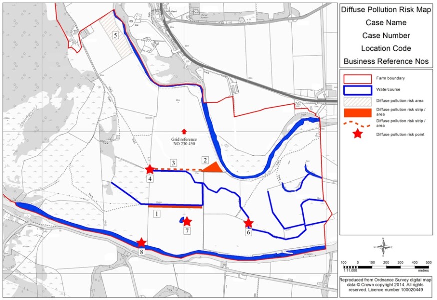
Using a map of an appropriate scale record as a line, point or shape as appropriate any diffuse pollution risks identified.
Depending on the size and nature of your land and the risks identified, you may either identify the risks on the Farm Environment map - available where the option/capital items also requires a Farm Environment Assessment or prepare a separate Diffuse Pollution Field Map, as shown in the example below.
Each of these points must be individually numbered on the map and noted in a corresponding table which will describe the diffuse pollution risk found and what action can be taken to deal with it.
The location of all surface waters such as burns, ditches, ponds and wetlands etc should also be recorded.
Diffuse pollution risk factors will vary depending on the type of farm (arable or livestock) and on local factors such as, proximity to watercourses, slope of land and soil types, access of livestock to watercourses, location of gateways and tracks etc.
Guidance on factors to consider when carrying out a field diffuse pollution risk assessment can be found in the accompanying guidance for the options such as ‘Alternative Watering’ and the options for the ‘Rural Sustainable Drainage Systems’. Risk factors will vary depending on land use. On grassland, diffuse pollution risks may originate from cattle tracks, drinkers or feeders close to watercourses or poaching and erosion on the banks of watercourses. On arable fields, soil erosion is likely to be the principal risk and will be influenced by soil type, cropping, slopes etc.
When the initial assessment is complete the next step is to decide what action and/or options might be appropriate to help reduce diffuse pollution risks.

| Number on map | Diffuse pollution risk | Action or potential options (for guidance only) |
|---|---|---|
| 1 | Grass field, cattle have direct access to ditch. Risk of poaching and erosion |
- Alternative watering facilities - Water margin in permanent grassland field - Stocking rate low - continue to monitor area and take action if poaching occurs |
| 2 | Low corner of arable field. Run-off exit point. Risk of causing erosion in lower field and eroded soil entering burn |
- Rural sustainable drainage system - sediment traps and bunds - Rural sustainable drainage system - pond - Creation of low input grassland to convert arable land at risk of erosion of flooding - Grass strip in arable field |
| 3 | Arable field sloping towards burn | - Grass strip in arable field |
| 4 | Risk of run-off from track entering ditch |
- Rural sustainable drainage system - sediment traps and bunds - Rural sustainable drainage system - swale - Livestock tracks |
| 5 | Long uninterrupted slope in arable field. Risk of soil erosion | - Grass strip in arable field |
| 6 | Gate close to burn. Risk of run-off from poached area around gate reaching burn |
- Hardstandings for troughs and gateways - Rural sustainable drainage system - sediment traps and bunds |
| 7 | Grass field, cattle have access to pond. Risk of poaching or erosion |
- Alternative watering facilities - Water margin in permanent grassland field - Continue to monitor area and take action if any poaching occurs |
| 8 | Grass field, cattle have access to ditch for drinking. Risk of poaching and erosion |
- Alternative watering facilities - Water margin in permanent grassland field - Continue to monitor area and take action if any poaching occurs |
Management map
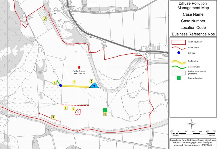
On a map and using a similar approach to the risk assessment mark the various actions that are planned to deal with the identified diffuse pollution risks.
Number each of the actions on the map to show their location. On a corresponding table, describe the actions to be taken or the options to be applied for – see example map and table below.
As for the field map, you may not need to have a separate diffuse pollution management map if the actions can be clearly shown in the Farm Management Map - available where the option/capital items also requires a Farm Environment Assessment.

You can either complete the table below or incorporate the information within the map key.
| Number of map | Action or option to be applied for (for guidance only) |
|---|---|
| 1 | Water margin fencing and alternative watering supply |
| 2 | Rural Sustainable Drainage System - Bund and Pond in corner field |
| 3 | Water margin |
| 4 | Swale and sediment traps to capture run-off from track |
| 5 | Grass strip in arable field |
| 6 | Move gate away from burn and create a hardstanding around gateway |
| 7 | Water margin with fencing and alternative water supply |
| 8 | Stocking rate low - continue to monitor area and take action if any poaching occurs |
Diffuse pollution steading assessment
You must complete this if you are applying for any of the following options:
- Rural Sustainable Drainage Systems – Wetland
- Rural Sustainable Drainage Systems – Sediment Traps and Bunds
- Rural Sustainable Drainage Systems – Swales
- Rural Sustainable Drainage Systems – Pond
- Hard Standings for Troughs and Gateways
- Livestock Crossing
- Livestock Tracks
- Managing Steading Drainage and Rural Sustainable Drainage Systems
- Pesticide Handling Facilities
- Water-use Efficiency – Irrigation Lagoon
*For Water – use Efficiency Irrigation Lagoon – the Diffuse Pollution Steading Assessment is only required where the lagoon will be filled with any water that was collected at a steading
You will need to produce a:
- Diffuse Pollution Steading Assessment Map
- List/table with all diffuse pollution risks identified and what improvements could be made to reduce diffuse pollution risks
- Diffuse Pollution Steading Management Map
- Diffuse pollution steading management table
Many of the diffuse pollution risks on a steading are associated with surface run-off and drainage. The assessment should focus on the management of surface water run-off, with a view to identifying the potential sources and pathways of pollutants. This should then be used to identify improvements which can be made to reduce pollution risk – see the ‘source -pathway-receptor' approach outlined above. Good management of drainage at the steading can help to significantly reduce these risks.
Reducing dirty water around the steading can: Leave more space for slurry or silage effluent storage. Cutting down dirty and contaminated areas around the steading will reduce the amount of water you have to collect and handle, saving time and costs on storage and application to land.
When assessing diffuse pollution risks from the steading consider the points below:
| Points to consider | Potential options | |
|---|---|---|
| Steading drainage | Are all guttering and down pipes working effectively? | |
| Are there any opportunities to reduce the volumes of dirty water produced through improved clean and dirty water separation? | Managing Steading Drainage and Rural Sustainable Drainage Systems | |
| Are there any opportunities to incorporate rural sustainable drainage systems (RSuDS) to treat run-off currently discharging direct to a water course? |
RSuDS – Swales RSuDS – Pond RSuDS – Wetland RSuDS – Sediment Traps and Bunds | |
| Slurry storage facilities |
- How many months slurry storage capacity have you got? - Would additional storage help reduce pollution risks on the farm? | Slurry Storage |
| Were the slurry stores built before 1 September 1991? If yes, have they been significantly enlarged or reconstructed since then? | ||
| Pesticide handling facilities |
- Is the pesticide store of sufficient capacity, protected from frost and bunded? - are there any drains or watercourses near the store that pesticide could enter if spilt? | |
| Is the run-off from the pesticide mixing, handling and washdown facilities adequate to avoid any risks of pesticide entering a drain or watercourse? | Pesticide Handling Facilities | |
| Silage clamps and silage effluent |
- Are the silage making facilities adequate in terms of capacity, permeability and structural integrity? - Is there sufficient storage available to collect and contain silage effluent? - Are silage bales stored in at least 10 metres from watercourses and drains? | |
| Is there a risk that run-off from silage bale storage area could enter a watercourse? | Managing Steading Drainage and Rural Sustainable Drainage Systems | |
| Fertiliser storage |
- Is the fertiliser storage area within 10 metres of a watercourse or otherwise pose a risk to the water environment? - Are liquid fertiliser tanks positioned and protected to minimise risk from accidental damage | |
| Oil storage |
- Are the fuel tanks adequately bundled? - Are there any watercourses or drains nearby? |
Diffuse pollution steading assessment map
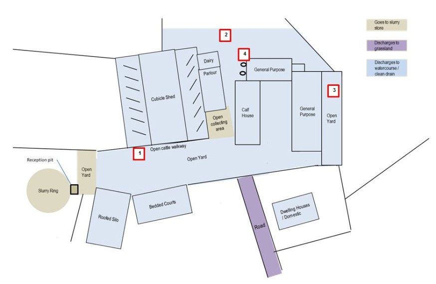
Create this map to identify the current diffuse pollution issues on the steading.
Using an appropriately scaled map of the steading, identify areas which produce:
- clean roof run-off and lightly contaminated yard run-off that currently discharges to a watercourse or clean water drain
- run-off that discharges to grassland
- midden run-off and run-off from open silos and indicate where the drainage goes
- dirty yards and run-off from silos and other drainage that discharges to the slurry or effluent store
Further information on identifying drainage types can be found within the guidance for the option – Managing Steading Drainage and Rural Sustainable Drainage Systems.
The map will help to illustrate where run-off on the farm originates and where it flows to and will help to identify areas of the farm where steps could be taken to help reduce the volumes of dirty water produced and reduce pollution risks.
Below is an example of how your map may look.

List/table with all diffuse pollution risks identified
Produce a list of any diffuse pollution risks identified and what improvement could be made to reduce diffuse pollution risks, see example table below:
| Number on map |
Diffuse pollution risk / opportunity |
Action or option |
|---|---|---|
| 1 | Cattle walkway discharging to clean drain | Use clean and dirty water separation methods to prevent the slurry produced on the walkway from contaminating the clean yard below. Channel the slurry from the walkway to the slurry storage facility |
| 2 | Lightly contaminated yard discharging direct to clean drain | Opportunity to intercept this lightly contaminated drainage and discharge to Rural SuDS swale and pond |
| 3 | Lightly contaminated yard discharging direct to clean drain | Opportunity to re-grade this clean concrete yard area to allow the run-off to discharge to a swale and local grassland |
| 4 | Fuel store not bunded | Bund fuel store |
List/table with all diffuse pollution risks identified - template
A blank diffuse pollution risks identified template can be accessed from the link below:
Diffuse pollution steading management map
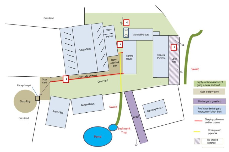
Create this map to identify the actions you are taking and the locations around the steading where works will happen.
On another map of the steading identify what works are proposed to take place to help improve the management of steading drainage and the location of any rural sustainable drainage systems.
Example diffuse pollution steading management map

Diffuse pollution steading management table
Create a table that references each works or action you propose to do from the steading diffuse pollution management map. Describe on the table how the works or action proposed will address the identified diffuse pollution issue and the option you have selected to achieve that.
Example Diffuse pollution steading management table below:
| Number on map | Action proposed | Option selected |
|---|---|---|
| 1 | A sleeping policeman / ramp and a channel will be installed along the length of the cattle walkway to contain and collect the drainage from this area. The sleeping policeman / ramp will prevent the run-off from the walkway contaminating the clean yard below. The channel will collect the run-off and convey it to the slurry storage facilities. | Managing Steading Drainage and Rural Sustainable Drainage Systems |
| 2 | This clean yard area currently discharges direct to a watercourse via an existing clean water drain. A sleeping policeman / ramp will be installed to prevent the lightly contaminated run-off from the top yard flowing through the heavily contaminated collecting area. The lightly contaminated drainage from the top yard will then be collected and conveyed via a new gulley and underground pipework to a new rural sustainable drainage system at the bottom of the yard | Managing Steading Drainage and Rural Sustainable Drainage Systems |
| 3 | This lightly contaminated concrete yard area which currently discharges to a field drain will be re-graded to allow the run-off to flow to local grassland |
Managing Steading Drainage and Rural Sustainable Drainage Systems RSuDS Swale RSuDS Sediment Trap RSuDS Pond |
| 4 | Bund fuel store | n/a |
Diffuse pollution steading management table - template
A blank diffuse pollution steading management template can be accessed below:
Recent changes
| Section | Change |
|---|---|
| Diffuse Pollution Risk Assessment |
Added text explaining Diffuse Pollution Risk Assessment comprises of two elements: - A field assessment map - A table detailing the Diffuse pollution risks and identifying potential opportunities/actions to minimise these risks. This can include identifying potential AECS options/capital items that could be delivered |
| Diffuse Pollution Steading Assessment | Added text to explain the requirements for the individual elements of the Diffuse Pollution Steading Assessment. Also, text to explain that for Water – use Efficiency Irrigation Lagoon – the Diffuse Pollution Steading Assessment is only required where the lagoon will be filled with any water that was collected at a steading. |
Previous versions
Download guidance
Click 'Download this page' to create a printable version of this guidance you can save or print out.
